2008/08/31

Europe, Italy - Dolomites

The Dolomites are a challenging and beautiful range of steep limestone peaks situated south of the Austrian/Italian border. The area is stretching out 80 kilometers east of Bolzano, which is split into different groups linked by a good road network. Many of the peaks are over 3000 meters high, giving long and demanding big wall routes up to 800 meters long. Some routes can be over 20-pitches long, however most them can be done in a single days outing or with an overnight stay in a mountain hut or lodge.

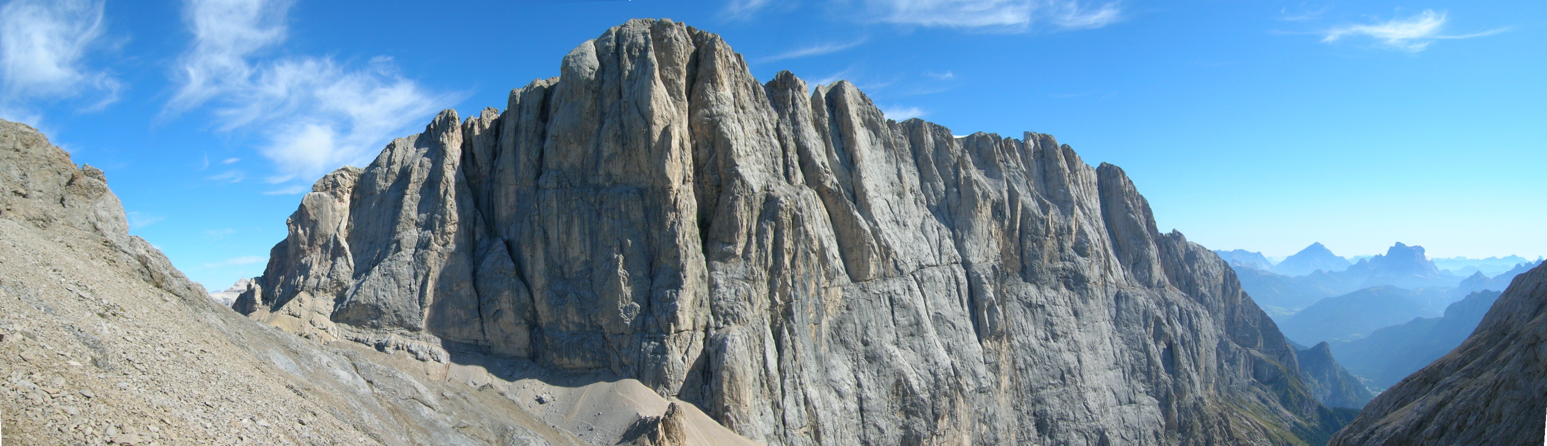
The highest mountain in the Dolomites is Marmolada, with its impressive 800 meters high and 3kilometers wide south facing limestone wall. All of the routes on this face are long and serious, and unique to the Dolomites, may take longer than a day to complete. It is wise to pack a bivouac bag. Unless you catch the expensive last cable car from the summit then the descent is down the north side of the mountain, which has the only glacier in the region! It is therefore recommended that in-step crampons and lightweight boots be worn.

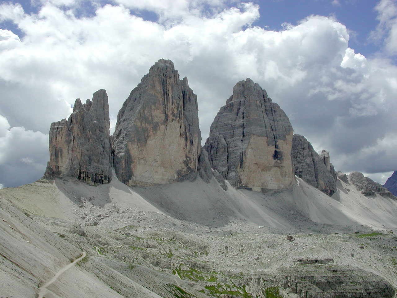
The north face of Cima Grande is one of the great alpine north faces and is breathtakingly steep - a real big wall. At 450 meters and 16-pitches long, and graded at UIAA V11- (UK E2 5c or French 6b) it is very sustained for long periods and therefore demands the prestige attached to it. However as with many of the routes in the Dolomites it is possible to aid across the difficult sections, which reduces this route to V1/A1 (UK E1 5B or French 6a).

The Sella Towers and Piz Ciavazes have a reputation for short approaches, easy descents, and well-protected routes that are not too long. However just on the other side of the Sella Pass is the Sassolungo area, where the routes are a much more serious undertaking and have an "alpine" experience about them.
Between Cortina and St Kassian is the Falzarego Pass, which offers some of the best rock climbing in the Dolomites. There are plenty of south-facing mid-grade routes; with short easy approaches; uncomplicated descents; and solid, well-protected routes.

Used pictures and information from http://en.wikipedia.org/, http://www.climb-europe.com/ and http://commons.wikimedia.org/

2008/08/11

Europe, Balkans, Greece - Kalymnos

My best friend Sonja and her boyfriend (now husband) Mike were my guests almost two years ago. During their visit I learned for an amazing place very close to Bulgaria - Kalymnos. They showed me a book with wonderful picture of this climbing paradise and make me dream about it.

The island of Kalymnos is about 300 kilometers south east of Athens, and 100 kilometers north west of Rhodes. It has 15 500 permanent inhabitants, most of whom live in Pothia, the capital of the island. It is well known as the sponge harvester’s island. It is surrounded by a number of small islands, only two of which are inhabited, Pserimos and Telendos. Pothia is a picturesque town built like an amphitheatre around the port. It has all the necessary facilities such as banks, a post office, a hospital etc, as well as an intense commercial life with shops selling all kinds of goods.

The island of Kalymnos offers rock climbing throughout the whole year although summer can be very hot and the winter weather is a little unpredictable. April and May are usually considered to be the best time for rock climbing and bouldering.
Rock climbing on Kalymnos started as recent at 1996 when Italian climbers discovered Kalymnos as a climber’s paradise. The island offers a variety of numerous lime stone rocks with different kinds of difficult degrees. The rock climbing is never monotonous as there are routes involving delicate moves or athletic routes on overhangs and roofs with holes and stalagmites.
Rock climbing on Kalymnos is still rather unknown at an international level and therefore you will not find the usual crowds and queues which are typical on the famous crags.
There are 24 equipped crags with 200 pitches , from F4c to F8a+ (all bolt protected, sport climbing), mostly facing west , but a few facing south .
The rock is excellent quality limestone, sharp at only a few points, without vegetation, and the pitches are equipped with rustproof bolts. At the moment almost all the routes are one pitch, but there are many possibilities for amazing two to five pitch routes. Indeed, apart from the quality, there is also the vast amount of rock available. The opened routes represent not more than 5% of the possibilities, while there are several equally good cliffs completely untouched that are awaiting their first route!
The ranking system in use is the French one. The grades of these routes are on the Kalymnos Route Database.

Used pictures and information from http://www.kalymnosinfo.com/ and http://www.kalymnos-isl.gr/

2008/08/05

Seven Summits


Bigger map

The Seven Summits are the highest mountains of each of the seven continents. Summiting all of them is regarded as a mountaineering challenge, first postulated as such in the 1980s by Richard Bass.
In fact there are two different The Seven Summits lists. The first Seven Summits list was proposed by Bass chose the highest mountain of mainland Australia, Mount Kosciuszko (2 228 m), to represent the Australian continent's highest summit. Reinhold Messner suggested another list replacing Mount Kosciuszko with New Guinea's Carstensz Pyramid (4 884 m). Neither the Bass nor the Messner list includes Mont Blanc. From a mountaineering point of view the Messner list is the more challenging one. Climbing Carstensz Pyramid has the character of an expedition, whereas the ascent of Kosciuszko is an easy hike.
Another disputed issue is Europe's highest mountain. Mount Elbrus (5 642 m) in the Caucasus is included on the both Bass and Mesner list, but there are people considering Mont Blanc (4 808 m) to be Europe's highest mountain.

The Seven Summits list by Mesner - Carstensz list

Africa

Africa's highest mountain Kilimanjaro is located in Tanzania. The highest point on Kilimanjaro is Uhuru Peak, on the volcano Kibo 5 895 metres.

Map of the area

Antarctica
Vinson Massif (4 897 meters) is the highest mountain of Antarctica, situated in the Ellsworth Mountains, located about 1 200 km from the South Pole. The mountain is about 21 km long and 13 km wide.

Map of the area

Australia and Oceania
Puncak Jaya (4 884 meters), sometimes called Mount Carstensz or the Carstensz Pyramid, is a mountain in the Sudirman Range, the western central highlands of Papua province, Indonesia. It's the highest summit for Australia and Oceania.

Map of the area

Asia
Mount Everest, also called Chomolungma, Qomolangma or Zhumulangma is the highest mountain on Earth, as measured by the height of its summit above sea level, which is 8 848 metres. The mountain, which is part of the Himalaya range in High Asia, is located on the border between Sagarmatha Zone, Nepal, and Tibet, China.

Map of the area

Europe
Mount Elbrus (west summit) stands at 5 642 meters and is considered to be the highest mountain in Europe; it is also the highest point of Russia. The east summit is slightly lower: 5 621 meters. The mountain is located in the western Caucasus mountain, Russia, near the border of Georgia.

Map of the area


North America
Mount McKinley or Denali "The Great One" in Alaska is the highest mountain peak in North America, at a height of 6 194 meters. Denali was renamed Mount McKinley for William McKinley, a nominee for president, by the Princeton graduate and gold prospector, William Dickey. Mount McKinley has a larger bulk and rise than Mount Everest. Even though the summit of Everest is about 2 700 meters higher as measured from sea level, its base sits on the Tibetan Plateau at about 5 200 meters, giving it a real vertical rise of a little more than 3 700 meters.

Map of the area

South America
Cerro Aconcagua (6 962 m) is the highest mountain in the Americas, and the highest mountain outside Asia. It is located in the Andes mountain range, in the Argentine province of Mendoza. Aconcagua is the highest peak in both the Western and Southern Hemispheres.

Map of the area