The end of the ridge and the end of the world... then nothing but that clear, empty air. There was nowhere else to climb. I was standing on the top of the world.
~ Stacy Allison, first American woman to summit Everest
Показват се публикациите с етикет Mountains. Показване на всички публикации
Показват се публикациите с етикет Mountains. Показване на всички публикации
2012/01/03
2010/04/29
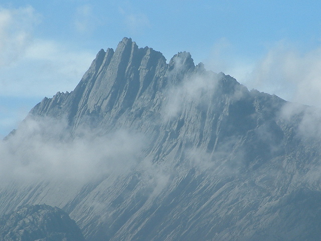
Europe, Greece, Mount Olympus (2917 m)
 Mount Olympus is the highest mountain in Greece. In 1981 UNESCO declared Mount Olympus a "International Biosphere Reserve" and in 1987 it was declared a National Park of Greece. The highest peaks there are Mytikas (2917m or 2918.8 according to the latest measurements), Skolio (2911m), Stefani (2909m), also known as "Zeus' throne", Skala (2866m, Agios Antonis (2815m), Profitis Ilias (2803m) and Toumba (2785).
NASA Earth Observatory
 Climbing Mount Olympus is a non-technical hike, except for the final 30 minute section from Skala summit to Mitikas summit, which is Yosemite Decimal System class 3 rock scramble. That class means scrambling with increased exposure; a rope can be carried but is usually not required; falls are not always fatal. It is estimated that 10,000 people climb Mount Olympus each year, most of them reaching only the Skolio summit (which does not involve rock scramble). Most climbs to Mount Olympus start from the town of Litochoro, which took the name City of Gods because of its location on the roots of the mountain. From there a road goes to Prionia, where the hike begins at the bottom of the mountain.
Mount Olympus
Coordinates 40°5′00″N 22°21′00″E
Live cams in the area - Plaka-Litochoro
Used information, pictures and video from http://en.wikipedia.org/, http://www.summitpost.org/ and http://www.youtube.com/
2009/04/27
Europe, Julian Alps, Slovenia - Triglav
This year the Sliven's Alpine club "Blue stones" have an anniversary - 50 years since it was establish. We are planning to climb Mt. Triglav & Mt. Grossglockner this summer to celebrate this remarkable anniversary. The first in the list is Mt. Triglav.
 Triglav (2864 m) is the highest mountain in Slovenia and the Julian Alps. The origin of Triglav name is still not completely clear. People used to be believe that it is home of Gods. Triglav means three heads. Although mountain is compact, from south it shows 3 heads. On the left is Rjavec (2568m), in the middle is main summit, Triglav (2864m) and on the right is Mali Triglav (2725m), which is actually just a shoulder, not a real peak.
 First on the summit where: Luka Korosec, Matija Kos, Stefan Rozic and Lovrenc Willomitzer. It happened on August 25th 1778. They climbed from Bohinj lake, over Velo Polje (where today is Vodnikov Dom hut), then to Ledine (where today is Planika hut) and further to Mali Triglav. Behind it, then notorious, ridge awaited them. They had to ride it because it is so narrow and on both sides is few hundred meters of sheer drop. Triglav was one of first important alpine peaks that were climbed. It was great feat for that time. First ascent from Krma valley happened in 1818.
Triglav's Via ferrata
Today Triglav is by far mostly climbed high peak in Slovenia and wider. Last 108 years, on the summit proudly stands Aljazev Stolp (more in objects section). Just below the summit is Stanicevo Zavetisce refuge, carved in stone. Four secured routes lead to Triglav. Some say that Triglav was humiliated with all that steel on the mountain. It became easy for anyone in better shape to climb Triglav, so today crowds can sometimes be unbearable and you have to wait on the ropes for long lines of people to pass as so many want to climb this magical mountain. Triglav regains respect in winter when security pegs and steel ropes are covered with snow. Then it is reserved only for experienced mountaineers and climbers. There are many huts around Triglav. In summer they are often overcrowded.
 North face of Triglav is most impressive in Julian Alps and Slovenia. 1200m high and around 3km wide face belongs to the alpine elite. Its name is written into the foundations of European alpinism. In the face there are numerous couloirs, towers or pillars, which divide it into few sections. In the eastern part most noticeable are Slovenian and German Steber towers. Most powerful is Centralni Steber, as name says, in the central part, which is steepest. In the western section is wild and high Jugova Grapa couloir. Above it is best known part of the face, Sfinga, almost smooth overhanging section.
Triglav and routes on its Stena
 First man to climb The Face was Berginc, a hunter from Trenta valley, in 1890. He climbed where today is Slovenska Smer, famous route suitable for experienced mountaineers that have some knowledge in climbing (up to III grade). First to climb central part were German climbers König, Reinl and Domenigg in 1906. Since then many routes were climbed in the face. The most famous route is Copov Steber, climbed in 1945 by Joza Cop and Pavla Jesih. The face is much climbed and represents to climbers what Triglav is to mountaineers.
Here are some routes:
Slovenska Smer route
Nemska Smer (German route)
Zimmer - Jahn exit (variation of German route): 800m, IV+
Bavarska Smer (Bavarian route): IV
Skalaska Smer route: IV-V
Copov Steber (Chop pillar) route: 1000m, VIII+
Prusik-Szalay and Kunaver-Drasler routes: 900m, VII+
Stopnice v Nebo (Stairs to the Sky): 500m, VI+
Zlatorogove Police (Zlatorog ledges)
More information about hiking routes could be found here.
Live cams in the area - Triglav weather; Triglav, Kredarica.
Used information, pictures and video from http://en.wikipedia.org/, http://www.summitpost.org/ and http://www.youtube.com/
2008/10/16
North America, USA, California - Yosemite National Park
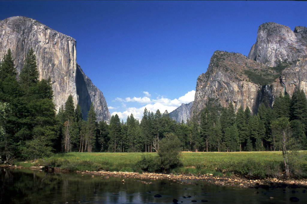 Yosemite National Park is located in the eastern portions of Tuolumne, Mariposa and Madera counties in east central California. The park covers an area of 3 081 km² and reaches across the western slopes of the Sierra Nevada mountain chain. Yosemite is visited by over 3.5 million people each year. Designated a World Heritage Site in 1984, Yosemite is internationally recognized for its spectacular granite cliffs, waterfalls, clear streams, Giant Sequoia groves, and biological diversity.
 Yosemite Valley represents only one percent of the park area, but this is where most visitors arrive and stay. El Capitan, a prominent granite cliff that looms over the valley, is one of the most popular rock climbing destinations in the world because of its diverse range of climbing routes in addition to its year-round accessibility. Granite domes such as Sentinel Rock and Half Dome rise 900 and 1,450 m above the valley floor. Complete list of Yosemite's Best Free Climbing Routes could be found here.
El Capitan is a 910 m vertical rock formation, located on the north side of Yosemite Valley, near its western end. The granite monolith is one of the world's favorite challenges for rock climbers.
The formation was named "El Capitan" by the Mariposa Battalion when it explored the valley in 1851. El Capitan ("the captain", "the chief") was taken to be a loose Spanish translation of the local Native American name for the cliff, variously transcribed as "To-to-kon oo-lah" or "To-tock-ah-noo-lah". It is unclear if the Native American name referred to a specific Tribal chief, or simply meant "the chief" or "rock chief". In modern times, the formation's name is often contracted to "El Cap", especially among rock climbers.
El Capitan, or El Cap, has two faces: the Southwest and the Southeast. Between the two faces is a protruding shelf called The Nose. The Nose is the most popular and famous route by which to climb El Capitan. The Nose was first climbed in 1958 by Warren J. Harding, Wayne Marry, and George Whitmore in 47 days. They used “siege” tactics, which meant using fixed ropes along the length of the route and establishing camps. The second ascent in 1960 took 7 days. The first single day ascent was accomplished in 1975. Presently, The Nose challenges climbers of all experience levels. Some of the earliest routes for climbing El Capitan are still the favorites; Salathe Wall on the southwest face, and the North America Wall on the southeast face, both climbed in the 60s. Other early routes include Dihedral Wall, West Buttress, and Muir Wall. Later climbs involve routes like the Wall of Early Morning Light, Zodiac, Mescalito, the Sea of Dreams, the Shield, the Pacific Ocean Wall, and the Jolly Roger. Today there are over 70 routes going up El Capitan, many of which link old routes and new ones. With that many routes, there is something to appeal to every level of experience and ability.
Climbing the Nose in June 2007 - Konrad Schlenkrich & Livio Urban & Thomas Johne (Germany)
Ascent of Zodiac (VI, 5.8, A3) on Yosemite's El Capitan.
Half Dome is a granite dome, located at the eastern end of Yosemite Valley — possibly Yosemite's most familiar sight. The granite crest rises more than 1 444 m above the valley floor.
As late as the 1870s, Half Dome was declared "perfectly inaccessible", but it may now be ascended in several different ways. Thousands of hikers reach the top each year by following a trail from the valley floor. The trailhead is only 3.2 km from Half Dome itself, but the circuitous route is 13.7 km long. The final ascent is accomplished by following a pair of metal cables raised on posts up the peak's steep but somewhat rounded east face. The cable route was constructed in 1919, but followed close to the route of George Anderson's October, 1875 first ascent made by drilling iron eyebolts into the smooth granite.
Alternatively, over a dozen rock climbing routes lead from the valley up Half Dome's vertical northwest face. Other routes ascend the south face and the west shoulder. The first modern technical route was the Regular Northwest Face route - originally climbed in 1957 by Royal Robbins, Mike Sherrick, and Jerry Gallwas. This 5-day ascent was the first Grade VI climb in the United States.
VIDEO-HIKE part of the Half Dome trail.
Used information, pictures and video from http://en.wikipedia.org/, http://www.extranomical.com/ and http://www.youtube.com/
2008/10/10
North America, USA, California - Joshua Tree National Park
 I learned about Joshua Tree National Park from my mate, Sonja. Later she got engaged there and that made this place one of my favorites in the US . It is located in southeastern California . Declared a U.S. National Park in 1994, it had previously been a U.S. National Monument since 1936. It includes over 3 196 km² of land. The park includes parts of two deserts, each an ecosystem whose characteristics are determined primarily by elevation. Below 900 m, the Colorado Desert encompasses the eastern part of the park and features natural gardens of creosote bush, ocotillo, and cholla cactus. The Little San Bernardino Mountains run through the southwest edge of the park.
The higher, moister, and slightly cooler Mojave Desert is the special habitat of the Joshua tree (Yucca brevifolia), from which the park gets its name. The dominant geologic features of the landscape are hills of bare rock, usually broken up into loose boulders. These hills are popular among rock climbing and scrambling enthusiasts. The flatland between these hills is sparsely forested with Joshua trees. Together with the boulder piles and Skull Rock, the trees make the landscape otherworldly. An interesting fact about Joshua Tree National Park is that five of North America 's 158 desert fan palm oases are located there.
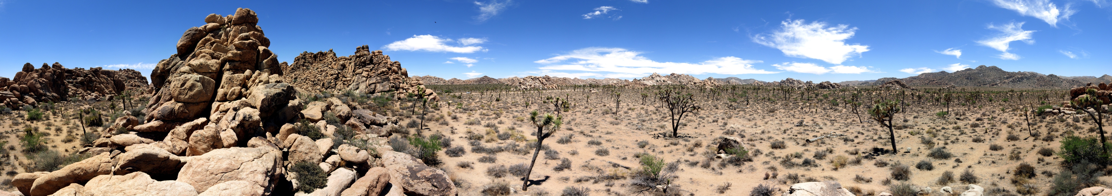 Joshua Tree attract climbers and bouldering enthusiasts from around the world with more than 400 climbing formations and 8,000 climbing routes. This climbing mecca is famous for its traditional-style crack, slab, and steep-face climbing.
Maps of the major climbing areas could be found here.
Used information, pictures and video from http://en.wikipedia.org/, http://www.nps.gov/jotr/ and http://www.youtube.com/
2008/09/20
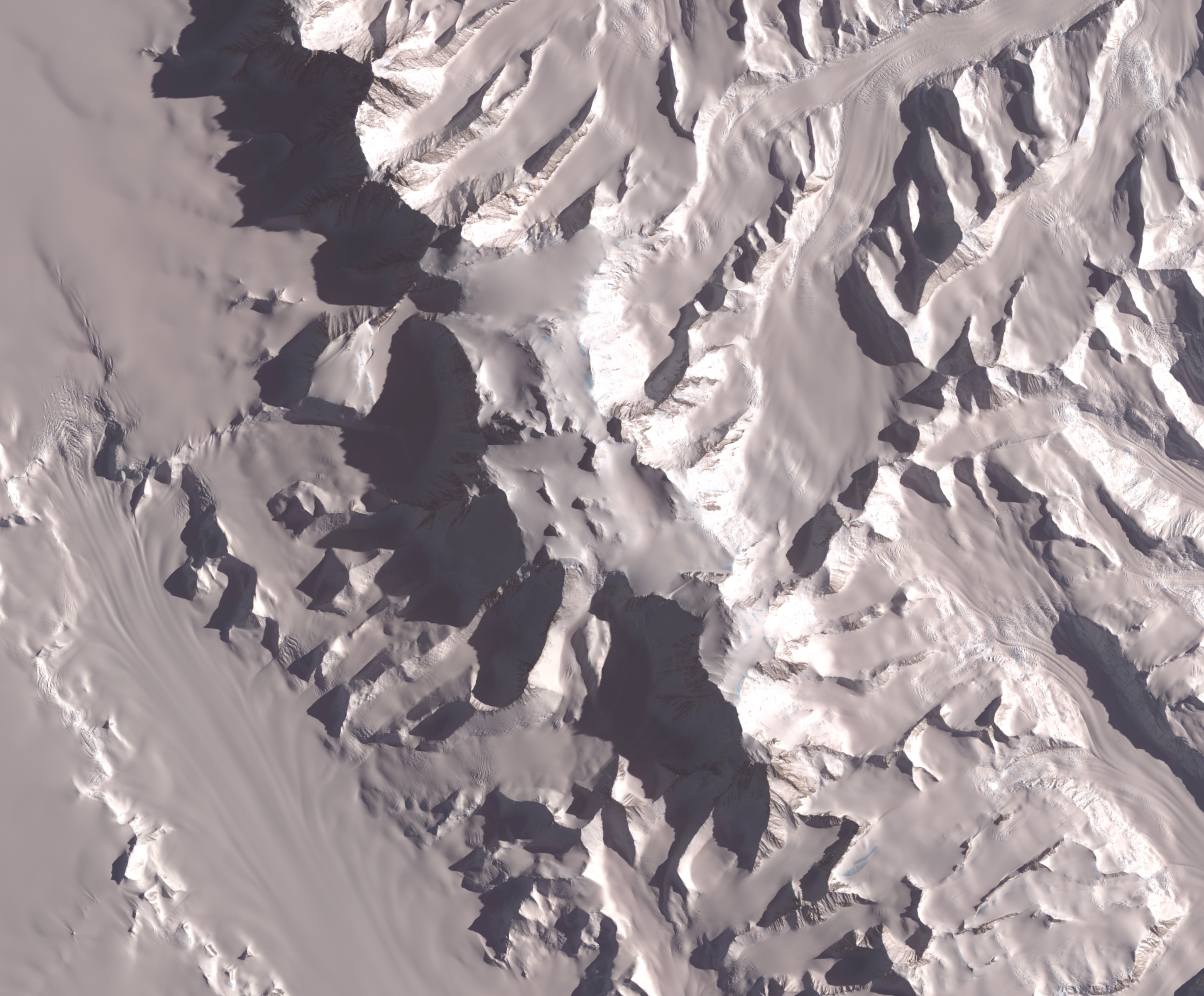
South America, Argentina - Patagonia
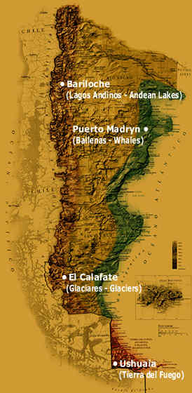 Patagonia is a geographic region containing the southernmost portion of South America. Mostly located in Argentina and partly in Chile, it comprises the Andes mountains to the west and south, and plateau and low plains to the east. The name Patagonia comes from the word patagon used by Magellan to describe the native people who his expedition thought to be giants. It is now believed the Patagons were actually Tehuelches with an average height of 1.80 m compared to the 1.55 m average for Spaniards of the time.
To the east of the Andes, it lies south of the Neuquén River and Colorado rivers, and, to the west of the Andes, south of 39°S, excluding the Chiloé Archipelago. East of the Andes the Argentine portion of Patagonia includes the provinces of Neuquén, Río Negro, Chubut, Santa Cruz, and Tierra del Fuego, as well as the southern tips of the provinces of Buenos Aires, Mendoza and La Pampa. The Chilean portion embraces the southern part of the region of Los Lagos, and the regions of Aisén and Magallanes. It excludes those portions of Antarctica claimed by both countries.
Chilean Patagonia - Torres del Paine /uploaded in YouTube by tlapse/
Patagonia National Park /uploaded in YouTube by patagoniavideo/
Patagonia attract tourists with the amazing nature and spectacular views. It's a place where the land, ocean and the sky are cross.
Here is located the most famous rock needle in the world - Cerro Torre. It's famous not for its height but rather its foul weather, its very long pointed shape and difficult technical climbs. Because the Patagonian Ice Cap is located near it Pacific storms are lifted and focused through a geographic effect that drops lots of precipitation and adds power to the winds making them fearsome. Even the toughest of climbers have to take a hard long look deep inside before climbing in the conditions that Cerro Torre can dish out. Climbs usually take three to eight days however it has been climbed in a day and a half. The weather on Cerro Torre is very bad with the 7000 foot south face seeming to have the worst weather. Often the top of Cerro Torre is covered in a crown of rime ice and some climbers have been known to call it a day just below this crown because of the difficulty of climbing the often over hanging ice.
Take a look at this video.
Patagonia - Cerro Torre /uploaded in YouTube by esalvaterra/
Used videos and information from http://en.wikipedia.org/, http://www.summitpost.org/ and http://www.youtube.com/
2008/08/05
Seven Summits
Bigger map
The Seven Summits are the highest mountains of each of the seven continents. Summiting all of them is regarded as a mountaineering challenge, first postulated as such in the 1980s by Richard Bass.
In fact there are two different The Seven Summits lists. The first Seven Summits list was proposed by Bass chose the highest mountain of mainland Australia, Mount Kosciuszko (2 228 m), to represent the Australian continent's highest summit. Reinhold Messner suggested another list replacing Mount Kosciuszko with New Guinea's Carstensz Pyramid (4 884 m). Neither the Bass nor the Messner list includes Mont Blanc. From a mountaineering point of view the Messner list is the more challenging one. Climbing Carstensz Pyramid has the character of an expedition, whereas the ascent of Kosciuszko is an easy hike.
Another disputed issue is Europe's highest mountain. Mount Elbrus (5 642 m) in the Caucasus is included on the both Bass and Mesner list, but there are people considering Mont Blanc (4 808 m) to be Europe's highest mountain.
The Seven Summits list by Mesner - Carstensz list
Africa
 Africa's highest mountain Kilimanjaro is located in Tanzania. The highest point on Kilimanjaro is Uhuru Peak, on the volcano Kibo 5 895 metres.
Map of the area
Antarctica
 Vinson Massif (4 897 meters) is the highest mountain of Antarctica, situated in the Ellsworth Mountains, located about 1 200 km from the South Pole. The mountain is about 21 km long and 13 km wide.
Map of the area
Australia and Oceania
 Puncak Jaya (4 884 meters), sometimes called Mount Carstensz or the Carstensz Pyramid, is a mountain in the Sudirman Range, the western central highlands of Papua province, Indonesia. It's the highest summit for Australia and Oceania.
Map of the area
Asia
 Mount Everest, also called Chomolungma, Qomolangma or Zhumulangma is the highest mountain on Earth, as measured by the height of its summit above sea level, which is 8 848 metres. The mountain, which is part of the Himalaya range in High Asia, is located on the border between Sagarmatha Zone, Nepal, and Tibet, China.
Map of the area
Europe
 Mount Elbrus (west summit) stands at 5 642 meters and is considered to be the highest mountain in Europe; it is also the highest point of Russia. The east summit is slightly lower: 5 621 meters. The mountain is located in the western Caucasus mountain, Russia, near the border of Georgia.
Map of the area
North America
 Mount McKinley or Denali "The Great One" in Alaska is the highest mountain peak in North America, at a height of 6 194 meters. Denali was renamed Mount McKinley for William McKinley, a nominee for president, by the Princeton graduate and gold prospector, William Dickey. Mount McKinley has a larger bulk and rise than Mount Everest. Even though the summit of Everest is about 2 700 meters higher as measured from sea level, its base sits on the Tibetan Plateau at about 5 200 meters, giving it a real vertical rise of a little more than 3 700 meters.
Map of the area
South America
 Cerro Aconcagua (6 962 m) is the highest mountain in the Americas, and the highest mountain outside Asia. It is located in the Andes mountain range, in the Argentine province of Mendoza. Aconcagua is the highest peak in both the Western and Southern Hemispheres.
Map of the area
Абонамент за:
Публикации (Atom)


